|
Evaluation of increasing susceptibility
of areas surrounding Kala Bagh Dam,
Pakistan to flood risk: A review

Amna Butt
Aisha Khan
Sheikh Saeed Ahmad
Department of Environmental Sciences,
Fatima Jinnah Women University,
Rawalpindi, Pakistan
Correspondence:
Amna Butt
Department of Environmental Sciences,
Fatima Jinnah Women University,
Rawalpindi, Pakistan
Email:
ambutt91@yahoo.com
Abstract
Natural
calamities destabilize the financial
status of the affected nation/country.
It destroys the persisting infrastructure
causing the destruction of accomodation,
common facilities and the health care
system. The 2010 Pakistan floods have
killed over 1,700 people and directly
destroyed the lives of over 20 million
people . Khyber Pakhtunkhwa was the
worst hit province which suffered
massive losses of human lives, infrastructure
and economy; and also caused serious
environmental hazards. The expected
heavy rainfalls of upcoming years
in this region of the country will
possibly lead to extreme flooding
throughout the Indus river basin,
thus increasing the flood risk and
additional losses. Since dams are
known to have a function for flood
management, development of Kalabagh
Dam is thought to be crucial for the
alleviation of future flood risk in
the province. However, at provincial
level there are still a few objections
regarding its construction but ample
water wastage and livelihood loss
caused by 2010 flood has brought its
importance in regards of flood management
to the forefront.
Key words: Natural disaster,
Kalabagh Dam, Flood management, Flood
Impacts, Flood prevention, Health
impacts, Risk awareness, Monsoon rains,
anthropogenic factors of flood, "La
Niña"
1. Introduction
Floods are natural occurrences around
the globe, predominantly caused by
events such as heavy rainfall, steep
slopes and topographic features of
an area along with the role of anthropogenic
activities (Khan and Mohmand, 2011).
They cause immense losses in terms
of human life, infrastructure and
property (Montgomery, 2006; Kirsch
et al, 2012). Pakistan, due to its
topography and rainfall patterns,
has records of floods varying in severity.
However, among them the most devastating
ones were the floods of 2010 and 2011
(Qureshi, 2011). Leading drivers of
the increasing flood damage in Pakistan,
especially in the Indus plain, are
the anthropogenic factors such as
global warming, extreme weather events,
increase in sea level, deforestation
,urbanization, economic growth and
changes in land use practices.
The widespread floods all over Pakistan
in the year 2010 (late July and August)
became a trigger for flood riots,
social unrest, and increasing concern
over spread of epidemic diseases.
It was claimed to be the worst naturally
occurring calamity of Pakistan's history
and was said to be caused by the unprecedented
monsoon rains which lasted for almost
two months. At the peak of flooding,
it approximately brought one-fifth
of total land area of Pakistan underwater
(Veresay, 2010). As shown in Fig.
1 the flooding was observed in the
majority of the forty-six of Pakistan's
135 districts and caused monetary
loss of about $9.7 billion (ADB-WB,
2012). Approximately 20 million people
were affected by flood that year in
terms of damage to their lives, homes,
crops and infrastructure (Straatsma
et al. 2011; Akhter, 2011; WFP, 2012;
Encyclopaedia Britannica, 2013) and
were displaced (OCHA, 2010). This
damage tended to have long lasting
effects not only on farmers' lives
and economically valuable crops but
also on schools (approximately more
than 10,000) and other physical infrastructure
(Akhter, 2011; Encyclopaedia Britannica,
2013). The effect on the economy,
including livestock, animal sheds,
fertilizers, agriculture crops, personal
seed stocks, agricultural machinery,
fisheries and forestry, was more than
any of the previously occurring losses
due to a natural catastrophe in the
region (FAO, 2012). Approximately,
80% of food reserves of Pakistan were
lost (Polastro et al, 2012).
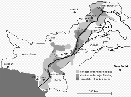
Figure 1: Map showing flooding
status of different districts of Pakistan
in the year 2010
(Source: Veresay, 2010)
2. Impacts of
2010 flood on Pakistan
Flood damage in Pakistan was most
evident in the districts of Nowshera
and D. I. Khan in KPK, Rajanpur and
Muzaffargarh in the Punjab, and Thatta,
Shikarpur, Jaffarabad and Jacobabad
in Sindh (ESP, 2010-2011).The flood
produced an adverse effect on the
health of the local population. 6.2
million consultations for dermatologic
conditions, gastroenteritis, malaria
and respiratory infections, were reported
to the World Health Organization (WHO)
from 50 districts of the total 64
affected districts between August
and September 2010 (Warraich et al.,
2011). The flood also resulted in
the destruction of the natural environment
and natural resources. It has caused
the erosion of forest land, killing
of wildlife, washing out of native
aquatic fauna, growth and distribution
of exotic flora and fauna, dispersal
of epidemic diseases, increase in
pollution, and destruction of the
habitats and previously existing ecosystems
(Khan et al, 2010).
2.1 Impacts of 2010 flood on KPK
About 22 July monsoon rains began
to fall in northwest mountainous region
of Pakistan leading to flash floods
in Balochistan, Khyber Pakhtunkhwa
and Punjab provinces (Akhter, 2011;
Encyclopaedia Britannica, 2013). Khyber
Pakhtunkhwa province was the worst
hit province due to a westerly weather
system combined with heavy and prolonged
monsoon rains in the area (Khan and
Mohmand, 2011). Table 1 shows the
Indus and Kabul river outflows in
different regions of KPK during the
2010 flood and their flow status.
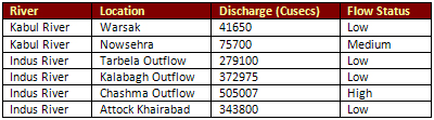
Table 1: Indus and Kabul river
outflows in KPK flood during 2010
Along with the destruction of human
lives and livestock (Provincial disaster
management cell, 2010), crops, irrigation
water supply system, infrastructure
and economy; 2010 floods also posed
serious environmental hazards in KPK
(Khan and Mohmand, 2011). The causes
of these floods were steep slopes
(topography), prolonged rainfall,
rapid and unplanned urban development,
deforestation, development of infrastructure
and high sedimentation rate (Khan
and Mohmand, 2011).
3. Future Risk
and implications of Flood
The late July - August 2010 monsoon
rains was 180% above normal in KPK,
Pakistan with the reports of 300mm
in excess on 29 July, 2010 as reported
by Sayah (2010), Slingo (2010), Vastag
(2011) and Oxley (2011) in their respective
analysis of 2010 floods in KPK Pakistan.
These rains are considered to be caused
by a combination of "La Nina"
(induced high sea surface temperatures),
strong winds (jet stream) and large
amounts of moist air over the Indian
Ocean (Oxley, 2011). The analysis
of these factors lead to the proposition
that in the upcoming years unusually
heavy rainfalls would be experienced
frequently in the northern areas of
Pakistan, due to global warming. It
is evident that the unusually heavy
rains in the northern areas of the
country caused the high levels of
extreme flooding throughout the basin
of the River Indus, that lead to the
record losses across every region
of Pakistan (Oxley, 2011). The soil
of the region will be prone to erosion
in the future and will also be a source
of siltation of streams and rivers
with pouring rains and high surface
flows. The decrease in vegetation
cover might contribute to surface
run off and will decrease the percolation
and aquifer revival rates. The loss
of farms, forests and linear plantations
on agricultural fields will lead to
economic stress on the communities,
as they will have to purchase energy
sources such as LPG cylinders or they
will cut trees for fuel wood causing
additional loss of vegetation cover.
The loss of agricultural crops, fruit
orchards, forests and natural vegetation
will affect the wildlife populations,
as these problems result in the loss
of cover, nesting sites, food resources
and habitat for them. The ultimate
result will be the exposure of wildlife
to hunters (Khan et al, 2010). The
floods incidents, if repeated, will
cause the destruction of social and
local community life and will cause
stress on the local population resulting
in many economical, occupational and
psychological impacts.
4. Kalabagh Dam
(KBD) Project and flood management
Flooding is a natural part of a river's
cycle and it only becomes catastrophic
when people are not well prepared
to cope up with it and property is
not appropriately planned and designed.
Many dams have the specifications
of controlling flood, but in some
cases dams actually cause floods (NFIP).
The floods of 2010 resurfaced the
debate about the Kalabagh Dam as flood
control is considered as one of the
major benefits of this dam. The Kalabagh
Dam site is 210 km downstream of the
Tarbela Dam and approximately 26 km
upstream of the Jinnah Barrage on
the River Indus (Pakistan Water Gateway).
Indus River rises in Tibet at an elevation
of about 18,000 ft. above sea level.
After flowing through the Himalayan
mountain ranges and then foothills,
it spreads into the Punjab plains
at the town of Kalabagh and flows
further 770 miles across the plains
before reaching the sea (Izhar-ul-Haq,
1984-85). The proposed design of the
dam presents the plan the construction
of a 260 ft. high rock-fill dam having
the maximum retention level at about
915 ft. Its reservoir would have the
working storage of an estimated 6.1
MAF. It will also have two spillways
on the right bank for the active distribution
of flood water for quick proper disposal.
It is also proposed that in the event
of probable floods, these spillways
will be able to discharge over 2 million
cusecs of water. The final power house
will be constructed on the left bank
and will have the final generation
capacity of 3600 MW (WAPDA, 1999).
The mean annual river flow at Kalabagh
is 90.00 MAF. It is due to the presence
of many additional nullahs and tributaries
that join the Indus River between
KB Dam and Diamer Bhasha Dam. So,
the mean volume of flood to be managed
at Kalabagh is about 2,200,000 cusecs
(Luna and Jabbar, 2011). The Kalabagh
dam has been thoroughly investigated
from multiple aspects since the inception
of its idea in 1952. These technical
(Izhar-ul-Haq, 1983; Luna and Jabbar,
2011; WAPDA, 2010) environmental and
ecological impacts (Kazi, 2001; Ali,
2006), social (Memon, 2002), economical,
power and energy provision (Abbasi
et al, 2013), and political impacts
(Mustafa, 2010; Feyyaz, 2011) have
been rigorously investigated by various
governmental, national and international
organizations, technical consultants
and experts, independent dam engineers
and political, social and environmental
experts.
As mentioned above, among the many
proposed benefits of developing the
Kalabagh dam (power generation, supply
of water for irrigation etc.) one
was flood alleviation. It was proposed
that the project will be helpful in
reducing the severity and frequency
of damage caused by floods in downstream
areas. It was proposed that the reservoir
will absorb some floods while others
will be abated significantly by refilling
the reservoir and the annual average
flood alleviation benefits to be derived
from the dam were estimated to be
Rs. 0.70 Billion (Pakistan water and
development authority, 2001; GOP,
2001). However, historical evidence
suggests differently such as the reported
prevalence of severe flood impacts
after the construction of other major
dams in Pakistan namely Mangla and
Tarbela (Water Sector Report, 1997;
Khan, 1999; Khan, 2003). This leads
KPK people to be concerned about the
development of Kalabagh dam over the
past years. This concern is based
on the serious threat to the survival
of Nowshera town and surrounding areas
due to prevalent high flood (as in
case of 1929) which they believed
will happen due to backwater effect
of Kalabagh dam. This effect is thought
by them to raise water level of Kabul
river and thus threaten the survival
of Nowshera town. Yet Bhatti, (2011)
argued that this concern is not valid
since various investigations such
as that of Water and Power Development
Authority of Pakistan (WAPDA) negated
this theory and stated that the backwater
effect will not affect the town as
it would end about 10 miles downstream
(WAPDA, 1999). Similar results were
obtained by the research of Malik,
(2005) and Malik, (1999) also argued
that Munda Dam project (Swat River)
will further provide protection to
the town against the flood as stated
by Bhatti, (2011).
Figure 2 shows that along with KPK,
other Provinces have also raised various
objections regarding KBD based on
the possible environmental and socio-economic
impacts of its construction (Ahmad,
2014; Rasheed, 2013; Bhatti, 2011;
Rajput, 2011; Khan, 1999). The specifications
of these objections are illustrated
in Table 2.
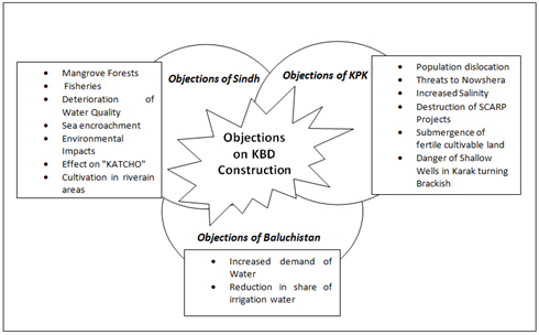
Figure 2: Oppositions to KBD construction
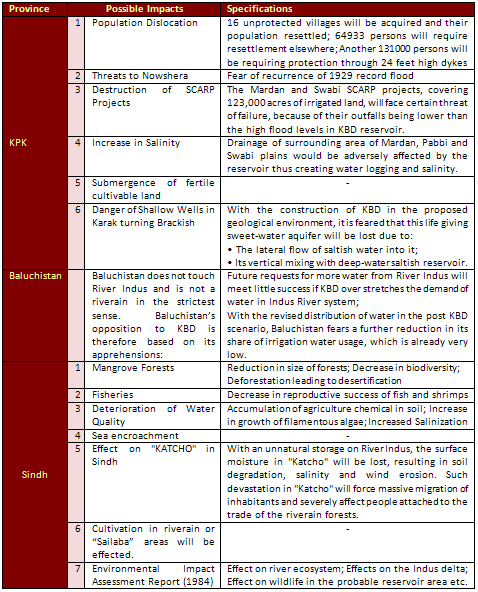
Table 2: Objections of Pakistani
Provinces against KBD Construction
based on its impacts
Research conducted on KBD from all
the aforementioned perspectives makes
its construction the most controversial
issue in Pakistan where many are opposing
it (Rasheed, 2013; Rajput, 2011; Khan,
1999) while others are supporting
it (Bhatti, 2011; Malik, 2005; Malik,
1999). It is yet to be ascertained
whether its harmful impacts overcome
the positive ones (such as flood prevention)
or vice versa.
5. Conclusion
Increasing climatic changes make it
a necessity to develop infrastructure
for water storage for upcoming dry
periods. Unfortunately such infrastructure
development is opposed by various
societal segments in Pakistan. Kalabagh
dam has particularly become an exceedingly
controversial project of Pakistani
history. Not only the province of
Khyber Pakhtunkhwa but also Sindh
has shown opposition to the dam construction
even though the evidence proved their
objections and reservations both baseless
and groundless. The project is not
only useful for economy and energy
generation but the loss of lives and
properties by the 2010 flood and ample
wastage of water has revealed the
importance of this dam in regards
of flood and water management. Estimates
revealed that 59 million acre feet
water passed through Kotri barrage
during flood and it is obvious that
large dams like KBD can prove to be
beneficial for flood prevention. However,
it should not be considered as the
only way of preventing the floods
in the KPK region and other measures
should also be adopted after the complete
study of the region.
References
Abbasi, A. H., Mehmood, F., and Wasti,
A. (2013). Revisiting the Kalabagh
dam in the light of the current gas
crisis. Science, Technology and Development,
Sustainable Development Policy Institute
(SDPI), Islamabad, Pakistan, 32 (3):
257-262.
Akhtar, S. (2011). The south asiatic
monsoon and flood hazards in the indus
river basin, Pakistan. Journal of
Basic & Applied Sciences, 7 (2),
20-34.
Ahmad, I. (2014). Kalabagh Dam-Development
or Disaster. Retrieved 21st May, 2014
from: http://www.sanalist.org/kalabagh/a-10.htm.
Ali, S.H. (2009). Resolving Environmental
Conflicts in Pakistan's Energy Policy,
in Powering Pakistan - Meeting Pakistan's
Energy Needs in the 21st Century,
ed. Robert M. Hathaway and Michael
Kugelman (Karachi: Oxford University
Press, 2009), 134.
Bhatti, M. N. (2011). The Problem
of Water Management in Diverse Societies:
Study of Kalabagh Dam Project in Pakistan.
Journal of Public Administration and
Governance, 1(2), 240-255.
Economic Survey of Pakistan, 2010-2011,
Pakistan: Flood Impact Assessment.
Special Section 2. Ministry of Finance,
Government of Pakistan. Retrieved
25th May, 2014 from http://www.finance.gov.pk/survey_1011.html
Encyclopaedia Britannica. (2013).
Pakistan Floods of 2010. Retrieved
8th May, 2014 from: http://www.britannica.com/EBchecked/topic/1731329/Pakistan-Floods-of-2010.
Food and Agriculture Organization
of the United Nations (FAO UN), Update
on agriculture- Pakistan floods. No.3.
(2010). Retrieved 29th May, 2014 from
http://floods2010.pakresponse.info/sitreps/FAO_Pakistan_Update_on_Agriculture_No_3_19August2010.pdf.
Haq, I. (1983). Site Selection Kalabagh
Dam Project, Working Paper No 469,
Dams Review Cell WAPDA, Lahore.
Izhar-ul-Haq. (1984-85). Paper 469.
Pakistan Engineering Congress 60th
Annual Issue , 87-102.
Kalabagh Dam Project. (1999). WAPDA
(Pakistan Water and Power Development
Authority). (1999). [Online]. Retrieved
10th May, 2014 from: http://www.wapda.gov.pk,/pdf/KBDAM.pdf.
Kazi, A. (2001). Kalabagh Dam: An
Ecological Disaster. The Frontier
Post Peshawar, Pakistan.
Khan, A., Khan, M. A., Said, A., Ali,
Z., Khan, H., Ahmad, N., and Garstang,
R. (2010). Rapid Assessment of Flood
Impact on the Environment in Selected
Affected Areas of Pakistan. Pakistan
Wetlands Programme and UNDP Pakistan.
Pp 35.
Khan, M. S., and Mohmand, Z. H. (2011).
Environmental Effects of Hazardous
Flood of 2010 in the province of Khyber
Pakhtunkawa (KPK), Pakistan, its Causes
and Management. Science International
(Lahore), 23 (2), 147-152.
Khan, S. R. (1999). The Case Against
Kalabagh Dam. Paper for the Citizen's
Conference on: "The Politics
of Water: Perspectives and Policies".
Commission on Environmental Economic
and Social Policy - South Asia and
Sustainable Development Policy Institute.
Khan, S.R. (2003). The Case Against
Kalabagh Dam. In Bengali, K (Eds.)
The Politics of Managing Water (pp.174-181).
Karachi: Oxford University Press.
Luna, B. A., and Jabbar, M. (2011).
Kalabagh- A superior dam designers'
view point. Pakistan. Engineering
Congress, 71st Annual Session Proceedings
Paper No. 688, 288-302.
Malik, B.A. (1999, November 14). The
Case of Kalabagh Dam. Daily Dawn.
Malik, B.A. (2005). Indus Water Treaty
in Retrospect. Lahore: Brite Books.
Memon, A.A. (2002). An Overview of
the History and Impacts of the Water
Issue in Pakistan. Presented at the
International Conference on "Sindh,
the Water Issue and the Future of
Pakistan" The World Sindhi Institute,
Washington, DC, USA.
Montgomery, C.W. (2006). Environmental
Geology. 8th edition, McGraw Hill
International Edition.
Mustafa, D. (2010). Hydropolitics
in Pakistan's Indus Basin, Special
Report 261, United States Institute
of Peace (USIP), United States of
America.
National Flood Insurance Program (NFIP),
"Dams", Retrieved 30th June
2014 from https://www.floodsmart.gov/floodsmart/pages/flooding_flood_risks/dams.jsp
OCHA (Office for the Coordination
of Humanitarian Affairs). (2010).
Pakistan floods emergency response
plan-Revision. Retrieved 11th May,
2014 from: http://www.humanitarianappeal.net.
Oxley, M. (2011). Field note from
Pakistan floods: Preventing future
flood disasters. JÀMBÁ:
Journal of Disaster Risk Studies,
3(2), 453-461.
Pakistan Water & Power Development
Authority, (WAPDA). (2001). Annual
Report 1999-2000.
Pakistan Water and Power Development
Authority, (WAPDA). (1999). Kalabagh
Dam Project, [Online]. Retrieved 14th
May, 2014 from: http://www.wapda.gov.pk,/pdf/KBDAM.pdf.
Planning Commission, Govt of Pakistan
(GOP). (2001). Ten Year Perspective
Development Plan 2001-11& Three
Year Development Programme 2001-04.
Polastro, R., Nagrah, A., Steen, N.,
Zafar, F. Inter?agency real time evaluation
of the humanitarian response to Pakistan's
2010 flood crisis. Retrieved 24th
May 2014 from http://daraint.org/wp-content/uploads/2011/03/Final-Report-RTE-Pakistan-2011.pdf
Provincial Disaster Management Cell.
(2010). Floods Damages Data.
Qureshi, A. S. (2011). Managing floods
in Pakistan: From Structural to non-structural
measures. Symposium on "Emerging
Phenomenon of Untimely Rains / Floods
- 2011 in Pakistan", 107-114.
Rajput, M.I. (2011). Inter-Provincial
Water Issues in Pakistan. Pakistan
Institute of Legislative Development
and Transparency (PILDAT). Retrieved
28th May, 2014 from: http://www.pildat.org/publications/publication/WaterR/InterProvincialWaterIssuesinPakistan-BackgroundPaper.pdf.
Rasheed, B. (2013). Impact Assessment
of Hydroclimatic Change on Water Stress
in the Indus Basin. Massachusetts
Institute of Technology (MIT). Retrieved
22nd May, 2013 from http://globalchange.mit.edu/files/document/Rasheed_MS_2013.pdf.
Sayah, R. (2010). More than 400 people
dead in Pakistan flooding. Retrieved
9th May, 2014 from:http://articles.cnn.com/2010-07-30/world/pakistan.floods_1_flood-victims-khyber
pakhtunkhwa-swat-valley?_s=PM:WORLD.
Slingo, J. (2010). Pakistan floods
and extreme weather in August 2010.
Retrieved 8th May, 2014 from: http://www.metoffice.gov.uk/news/in-depth/extreme-events.
Straatsma, M., Ettema, J., and Krol,
B. (2011). Flooding and Pakistan:
causes, impact and risk assessment.
Retrieved 2nd May, 2014 from ESA,
ITC: http://www.itc.nl/flooding-and-pakistan.
Vastag, B. (2011). Pakistan floods
highlight weather-data gaps. The Seattle
Times: 19 Feb. Retrieved 11th May,
2014 from: http://seattletimes.nwsource.com/html/nationworld/2014266933_pakfloods20.html?syndication=rss.
Veresay, A. (2010). Disastrous Flood
in Pakistan - dropping of the Indo-Australian
plate. Earth changes and the Pole
shift. Retrieved 26th April, 2014
from: http://poleshift.ning.com/profiles/blogs/disastrous-flood-in-pakistan.
Warraich, H. Zaidi, A.K., Patel, K.
Bull. (2011). Pakistan Health Cluster
- Floods in Pakistan. Bull World Health
Organ; 89(3): 236- 237.
Warraich, H., Zaidi, A. K., Patel,
K. (2011). Floods in Pakistan: A public
health crisis. Bulletin of the World
Health Organization 2011, 89(3), 236-237.
Water sector report. (1997). Climate
Change Impact Assessment and Adaptation
Strategies.
World Bank. News & broadcast (WBNB).
(2012). - Asian Development Bank (ADB)-World
Bank (WB) assesses Pakistan flood
damage at $9.7 billion. Press Release
No: 2011/134/SAR. Retrieved 22th May
2014 from http://web.worldbank.org/WBSITE/EXTERNAL/NEWS/0,,contentMDK:22733998~pagePK:3
370~piPK:34424~theSitePK:4607,00.html
World Food Programme (WFP).(2010).
Pakistan flood impact assessment.
Retrieved 29th May, 2014 from http://home.wfp.org/stellent/groups/public/documents/ena/wfp225987.pdf.
|